Science at
Vallis Ranch
The quality and chemistry of the water, soils and forage at Highland Vallis are exceptional. The climate is driven by moisture being lifted and condensing over the mountains which are not going away. Below is a discussion of these and other elements of the science of Highland Vallis. Topics include Migmatites; a Very Long Unconformity; Plate Tectonics, Farallon and Shatsky; Mountains, Minerals, Rifts and Volcanos; Highland Vallis Soils; Highland Vallis Forage; Highland Vallis Water; and Highland Vallis Climate.
Migmatites
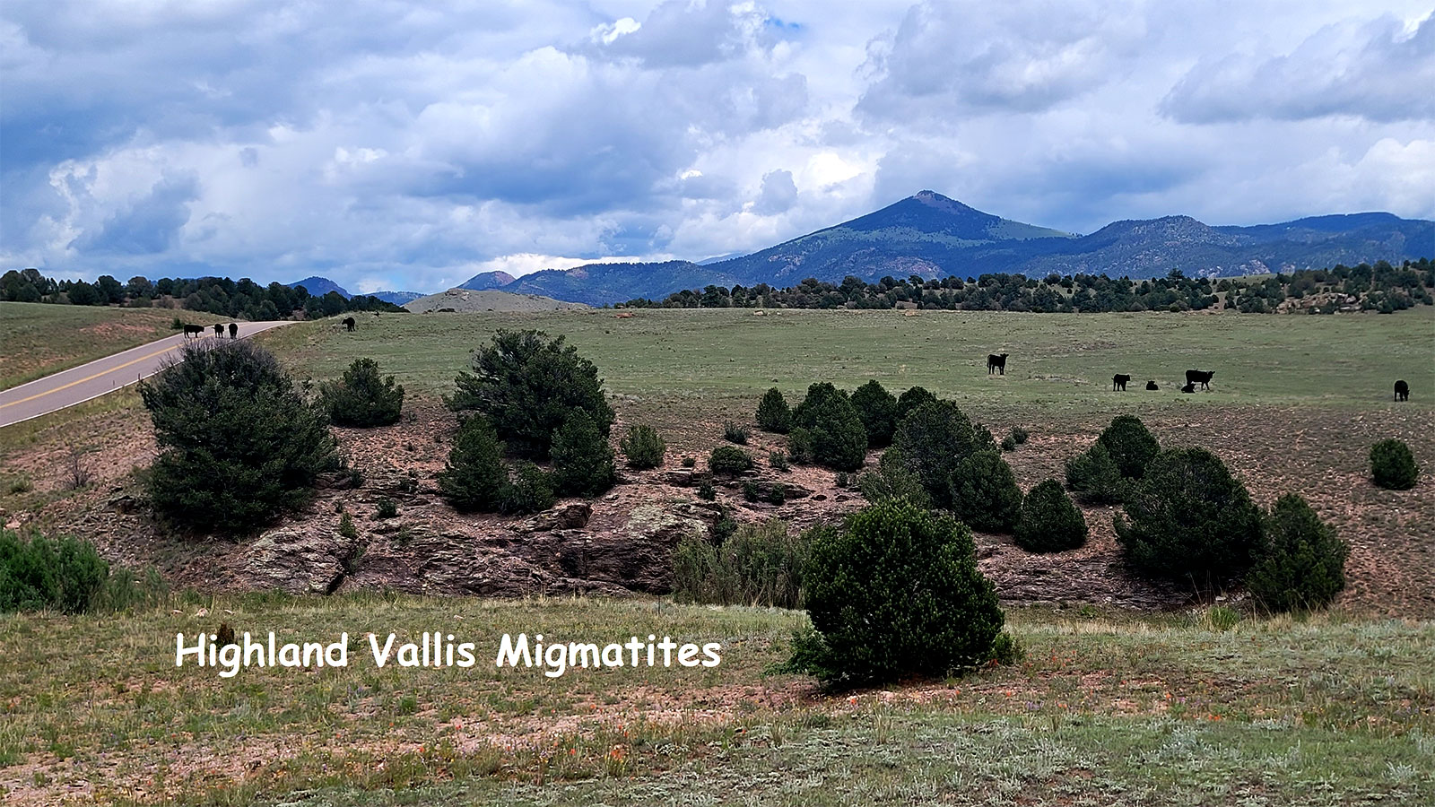
The oldest outcropping rocks on the ranch are called migmatites. They are a transition phase between a metamorphosed sedimentary rock (mostly a metamorphosed mudstone) and an igneous rock (mostly a granite). This rock begins as a shale, then was metamorphosed into slate, schist, gneiss then partially melts into an interbedded igneous granite. The following discussion will shed light on the formation of these oldest rocks at Highland Vallis.
Geologic processes do lots of things, one of which is to sort and segregate materials. For example, under windy dry conditions, coarser sand materials are left behind to form sand dunes while the finer materials are blown away to a distant location. The materials are sorted and separated according to their density and aerodynamics. Similarly but different, in Plate Tectonics, more dense basalt racks which make up ocean basin floors tend to be subducted down and under and the less dense granitic rocks tend to float upwards. These lighter, less dense granites then amalgamate, and make up our continents. Our existing North American continent is actually an amalgamation of older, smaller, continents. The following diagram from Wikipedia Wyoming Craton gives a simplified insight as to the geologic complications of the formation of our existing continent. Essentially, each area is its own microcontinent in the formation of the existing North American Plate.
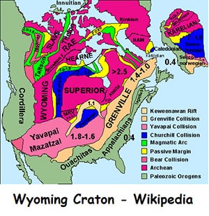
As these smaller micro continents are drifting together in the formation of the larger continent, basins are forming and materials are being shed from the smaller continents into the basins to form sedimentary rocks – shales for example.
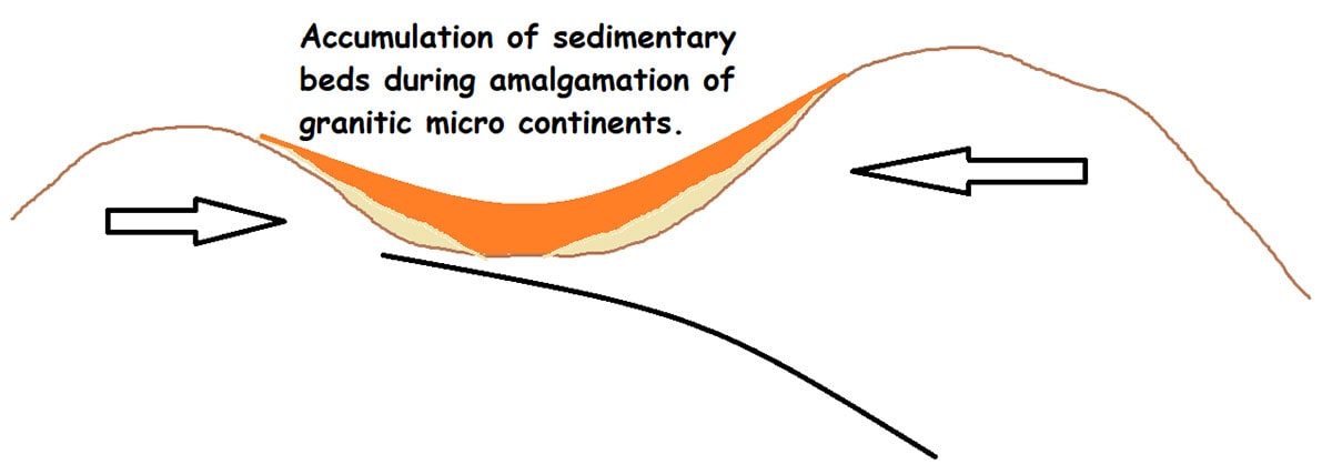
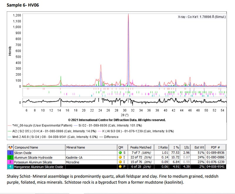
The Highland Vallis story begins about 2 to 2.5 billion years ago which is about half way through the age of the earth. These smaller previously formed granitic microcontinents are drifting together and shedding material into the existing basins. This is the origin of the Highland Vallis migmatite materials and some of the oldest rocks on the continent. The chemistry of these rocks suggest that they were originally a kaolinitic mudstone. Kaolinite typically forms from the breakdown of minerals in a hot humid environment – a tropical environment. The following XRD analysis gives the mineral assemblages of the shaley / schistose end of the migmatite consisting of quartz, kaolinite and microcline – a sandy mudstone with some potassium feldspars.
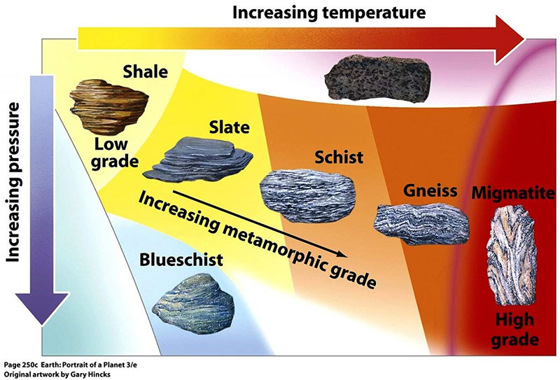
In the following billion years and more, these original sedimentary rocks, mostly mudstones, are buried and begin the transition from sedimentary rocks through metamorphosed rocks eventually to melted granitic rocks. The following diagram helps to understand this process from shale (mudstone / clays) to migmatite.
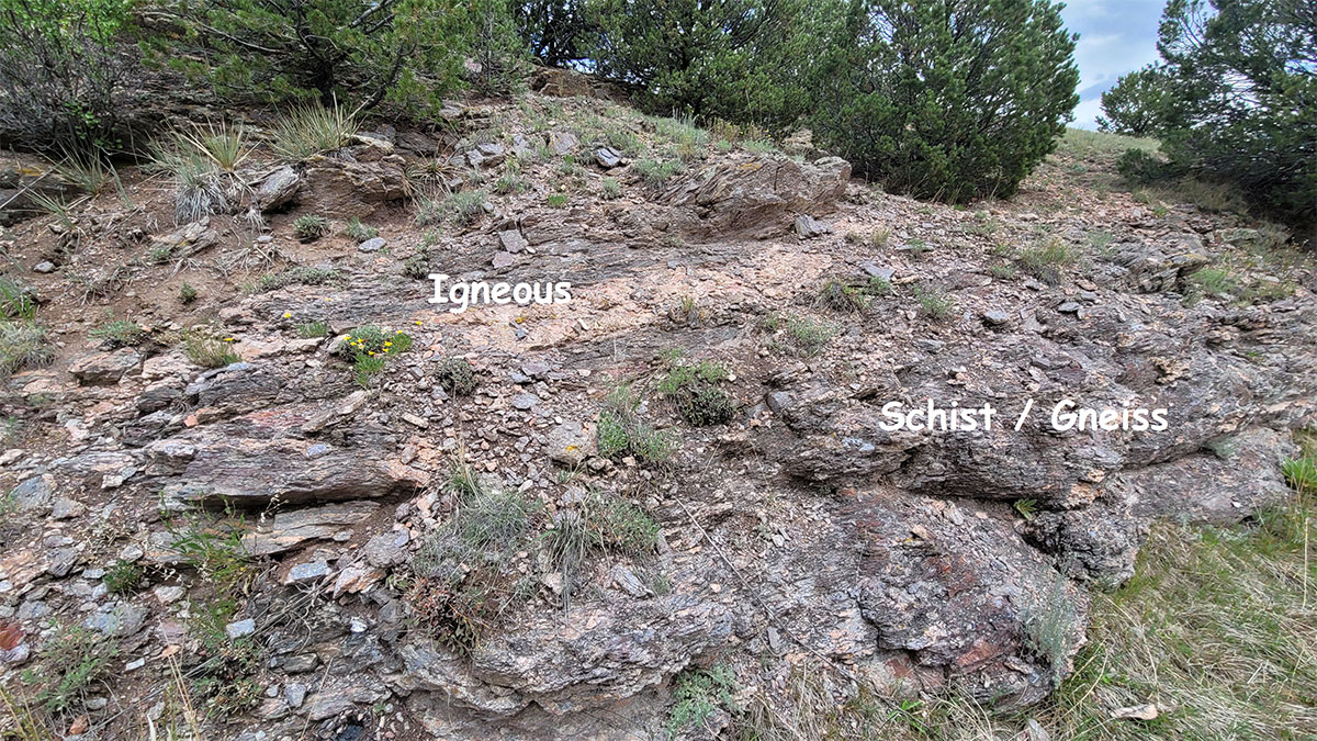
The following image is that of an actual migmatite on Highland Vallis, this is one with a particularly thick (about 1 foot) igneous seam within the schistose (unmelted) material.
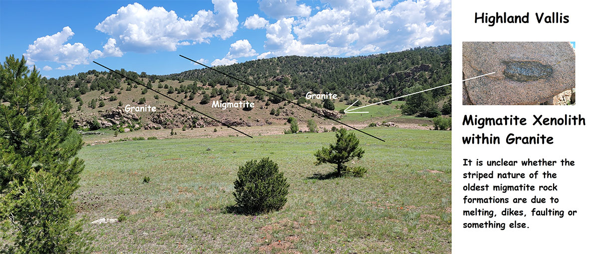
To be fractal is to be similar as scale is changed. In other words, what is seen on the small scale is also seen on the large scale and vice versa. There is a “fractal-like” appearance to these older migmatite rock formations. I see an alternating igneous – metamorphic (migmatite) trend in the large-scale outcrops that is similar to the small-scale individual rocks. It is unclear whether these are alternating melts, dikes, faults or something else. This fracture trend is north – south, seen across the ranch and probably contributes to the topographic low of the area. In the following image, a migmatite band is flanked on either side by a granite. Within this granite is a xenolith or inclusion of the migmatite within the granite. This suggests to me that the granite was once the migmatite and that is has completely melted into the granite, that is, all but the xenolith. However, there could be many alternate explanations.
A Very Long Unconformity
Imagine your retired Uncle Albert is going to pull a family album together. He gathers all of the family photos and history from 1850 forward. Uncle Albert likes a cocktail and cigar in the evenings. One evening he drifts off to sleep after spending the day working on the family album, the lit cigar falls out of his hand and onto the stack of old newspapers and catches on fire. Poor Uncle Albert and all of the family information is gone, everything is lost in the fire.
The above image reflects the human vision of a geologic unconformity. It is not that things didn’t happen, it’s just that we lost the direct record of them. We still know much, we would know the family went through the Civil War, WWI, Roaring 20’s, Depression, WWII, Korean Conflict, Vietnam War and on and on. Unfortunately, the photo of great grandad in a WWI uniform is now lost forever.
At Highland Vallis there is an unconformity from approximately 2 billion years ago to approximately 35 million years ago. A lot happened during this time, truly a lot, but those rocks that represent this time period are now missing. There are two things to remember regarding this unconformity: First, things did happen we just don’t have a record of them at this particular location; and second, because the rocks are gone, the missing rocks are not having an impact going forward. That is, the missing rocks are not having an impact on such things as current soil development or grass or forest growth. As a result, we will let most of this time go without discussion but it is an important fact to keep in mind.
Plate Tectonics, Mountain Building, Farallon and Shatsky
Starting about 160 million years ago, in the previously mentioned unconformity and in a plate tectonic sense, North America began drifting westward, away from Africa and Europe. Simultaneously, located west of North America (in the Pacific) was another plate called the Farallon Plate. This continental plate was drifting eastward. Associated with this plate were probably island arcs (think of Alaska’s Aleutian Islands) and possibly an island referred to as the “Conjugate Shatsky Rise.” Shatsky was probably an island much like Iceland is today. Iceland is splitting down the middle, one half going east, towards Europe, the other half is moving west. Assuming Shatsky did something similar, the west half is now over close to Japan and east half slid underneath North America.
Also, this Farallon Plate with all of its complications, did not simply dive off into the deeper part of the Earth’s mantle immediately as many plates do, but in fact hung in shallower and for a longer distance. What this means is, North America has had a pretty bumpy ride over the Farallon Plate.
The following illustrations are to help you to visualize this event of western North America sliding over this older Farallon Plate. Generally this process in divided geologically between two orogenies (Mountain building periods) the Sevier and the Laramide.
Note the “double subduction” of the Farallon Plate which is supported by actual seismic data.

Mountains, Minerals,
Rifts and Volcanos
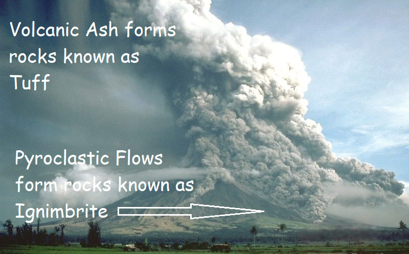
With the background provided in the previous sections about the North American Plate sliding west over the east drifting Farallon Plate with its rough topography, we are now better able to understand the mountains, volcanoes, pyroclastic flows and mineral development of Colorado and Highland Vallis’ relationship within this area.

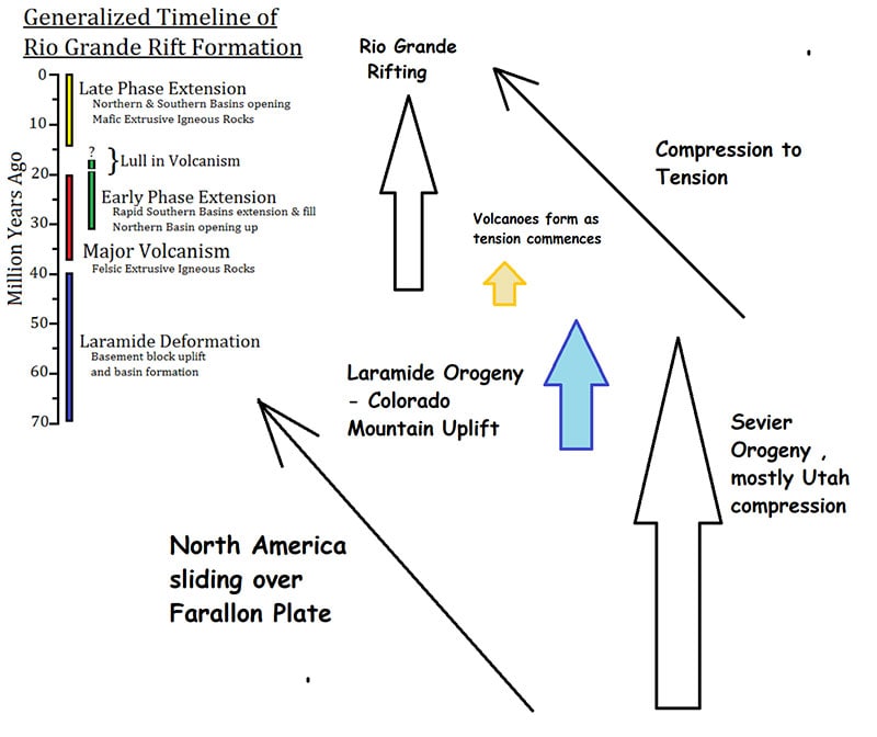
First, think about the mountains, think about an entire continental plate sliding underneath our own plate. There are three episodes, two primary mountain building episodes and a basin forming episode. The Sevier Orogeny and the Laramide Orogeny are compressional events and the Rio Grande Rift is an extensional or tensional event.
The Sevier (pronounced “severe”) Orogeny is really the precursor to Colorado mountain building. Think more of this event affecting Utah and the age range of 160 to 50 million years ago. But, to understand the complete history, you should begin by being aware of this beginning orogeny.
Next is the primary Colorado mountain building orogeny – the Laramide. Compared to Sevier, the Laramide is further east (in Colorado) and younger (80 to 30 million years ago). So, the Sevier – Laramide Orogenies together is more of a west to east progression of mountain building as our continent drifted west over the Farallon Plate.
Finally, after this progression of compressional forces, we begin to change to extensional forces and the continent begins to pull apart or stretch. An excellent human scale example of this is a chiropractor’s traction machine – it lifts and stretches the back. A similar thing happens within a continental plate: lifting, relaxing and releasing pressure. A decrease in pressure within the continent, and especially a magma chamber under or within a continental plate, can facilitate the formation of gases and bubbles within the magma. This is not unlike a shaken-up Coke bottle with the lid coming off. The result is explosive volcanos with tuffs and ignimbrite rock formations being formed. A tuff formation is the rocks formed from an ash fall of a volcano and an ignimbrite is what is formed from a pyroclastic flow coming down and spreading out from the volcano. See the opening illustration of this section for a visual.
Also associated with the tensional or extensional situation, the earth expands and gravity pulls down forming basins such as the Tularosa Basin with White Sands National Monument in New Mexico or the Alamosa Basin in Colorado and possibly the Yampa Valley of Northern Colorado. Below is an illustration to help with visualization of the timing of these events. The different arrows give an indication of the relationship and lengths in millions of years of the events. Use this illustration by looking from the bottom up.
Rifting is the uplift and separation or extension of a continent. It results in tensional forces and basins or topographic lows. This may seem counter intuitive to have an uplift or rise result in apparent lower topography but mathematically a certain amount of land is being spread over a larger area. The basins “fall” into the extra space created. Typically, this forms from a linear heat source from the deeper parts of the earth, the Mantle.
Two very important aspects of rifting are a deep-seated heat source and the distance between the heat source and the surface is less than average. This causes shallow heating, heats and moves fluids, allows for magma formation, the shallowness allows for a decrease in pressure on the magma resulting in gaseous volcanos and the fractures formed with the rifting allow for conduits for fluid and magma movement formingboth volcanos and magmatic dikes.
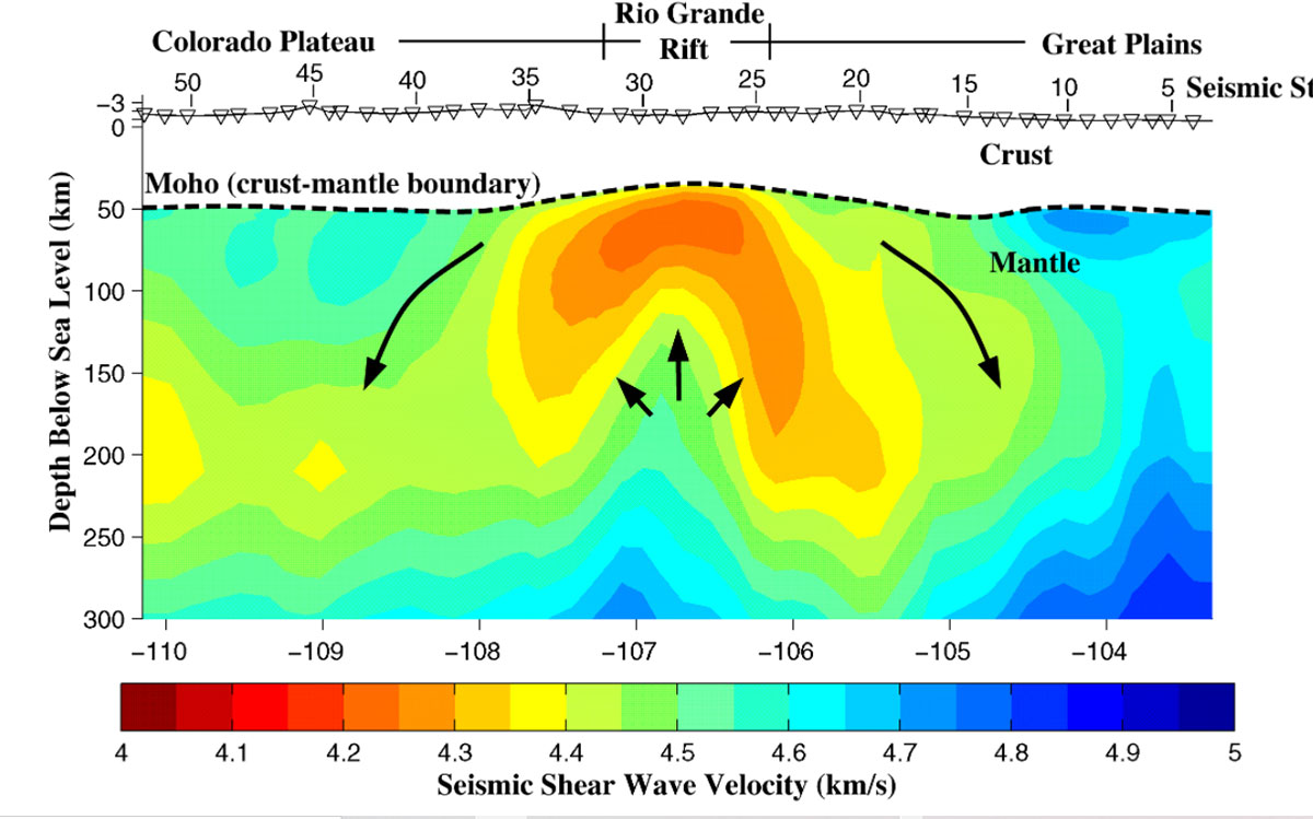
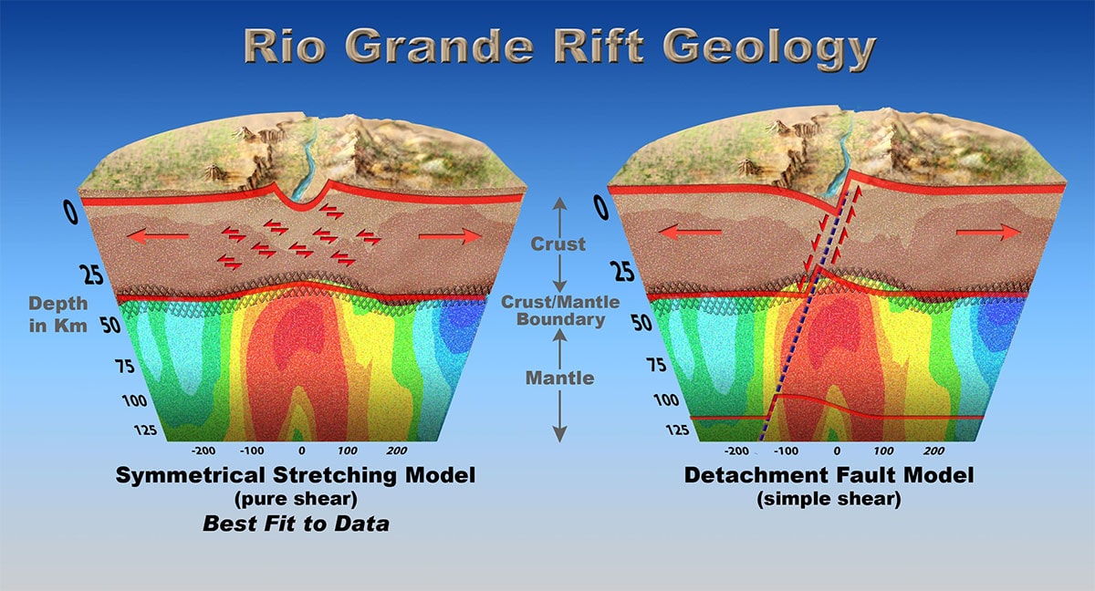

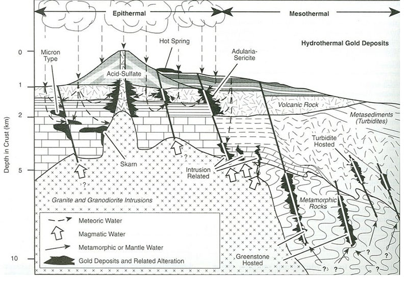
The primary linear Colorado Mineral Belt has produced in the range of 25 million Troy oz of gold among other minerals and likely started in the Pre-Cambrian and maybe associated with the original formation of the basin that produced the migmatites at Highland Vallis. The linear nature of the trend suggests a possible fracture or suture between two micro continents then reactivation may have occurred during the Sevier Orogeny and the Laramide Orogeny. Finally, during activation of the Rio Grande Rifting and volcanics we had magma and fluids moving up and along the fracture zone. This would likely result in the deposition of the minerals.
The Colorado Mineral Belt is conventionally described as a NE-SW trend but there are also other deposits in Colorado that could be inferred to promote a secondary trend, an arc trend that ties the ends of the linear belt. The Cripple Creek volcanic related gold deposit is away from the linear trend and on this arc trend. It appears to be fracture related hydrothermal deposition after volcanic.
The diagrams of Cripple Creek indicate a carbonate sedimentary country rock area (meaning sedimentary rocks prior to the volcanics). However most of the regional maps indicate the country rocks are migmates being the same found at Highland Vallis. Perhaps the Cripple Creek country rocks are a different lithofacies of the migmatites found at Highland Vallis. Possibly it is more of a shelf carbonate than the deeper shale kaolinite Notice the metamorphosed turbidites on the flank of the main feature on the following diagram, this would be associated with shale clastics.
So, the gold, besides being in the throat of the Cripple Creek volcano, seems to be hydrothermal (low to medium temperature) and associated with the faults and fractures.
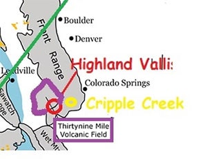
At Highland Vallis there are tuffs and ignimbrite outcrops formed from volcanics scattered across the ranch, they are the uneroded remnants of several layers formed from the volcanos of the area. These are likely interbedded between Cripple Creek associated volcanics and 39 Mile Volcanics which are principally located to the north and west. The 39 Mile volcanics are the same group of volcanics associated with the burial and preservation of trees at Florissant Fossil Beds National Monument located north of Highland Vallis.
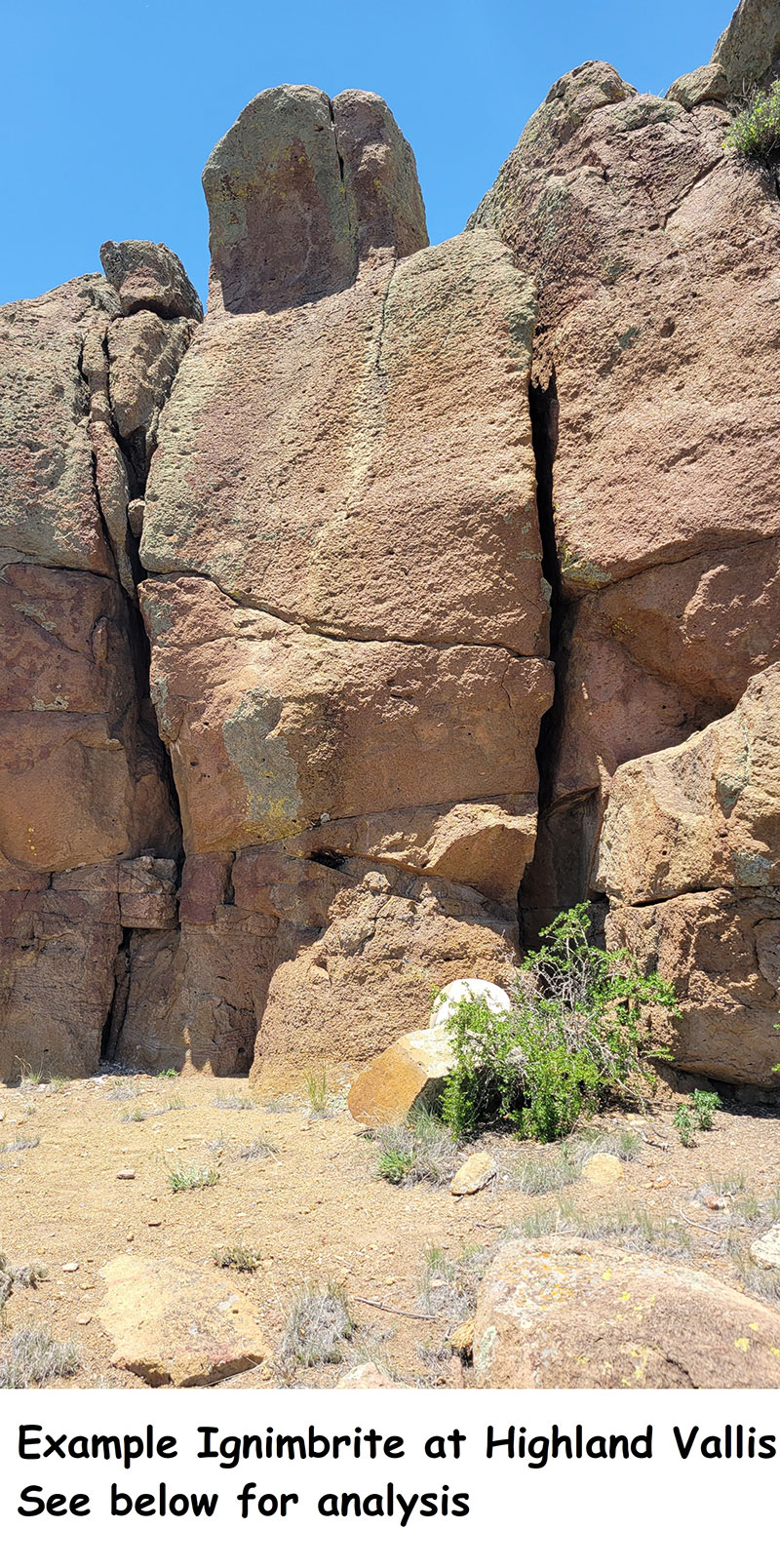
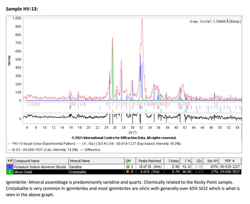
The chemistry of the volcanics is variant from intermediate (andesitic) to felsic (rhyolitic) meaning a good combination and mix of elements. The photo below is of a beautiful felsic ignimbrite outcrop with abundant christobolite and sanadine. A nearby and probably associated volcanic outcrop (Rocky Point sample) has a much higher sanadine plus vermiculite is seen which would greatly increase the quality of the soils that derive from these rocks. Although not a lot of vermiculite in this sample it does give a window into the decomposition of these rock formations.
At Highland Vallis there are tuffs and ignimbrite outcrops formed from volcanics scattered across the ranch, they are the uneroded remnants of several layers formed from the volcanos of the area. These are likely interbedded between Cripple Creek associated volcanics and 39 Mile Volcanics which are principally located to the north and west. The 39 Mile volcanics are the same group of volcanics associated with the burial and preservation of trees at Florissant Fossil Beds National Monument located north of Highland Vallis.
The chemistry of the volcanics is variant from intermediate (andesitic) to felsic (rhyolitic) meaning a good combination and mix of elements. The photo below is of a beautiful felsic ignimbrite outcrop with abundant christobolite and sanadine. A nearby and probably associated volcanic outcrop (Rocky Point sample) has a much higher sanadine plus vermiculite is seen which would greatly increase the quality of the soils that derive from these rocks. Although not a lot of vermiculite in this sample it does give a window into the decomposition of these rock formations.

Highland Vallis Soils
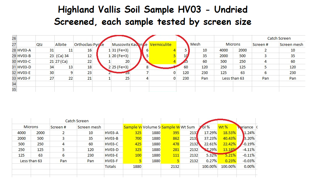
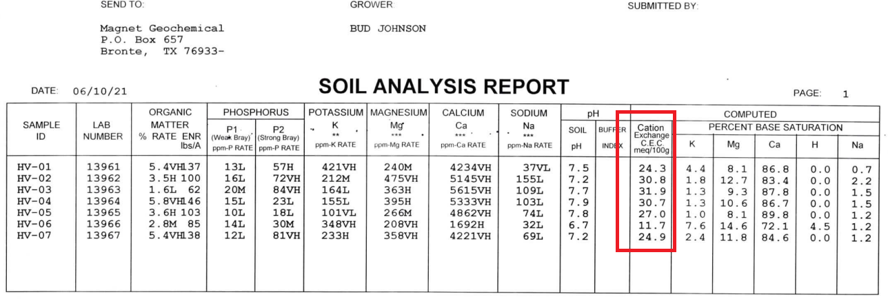
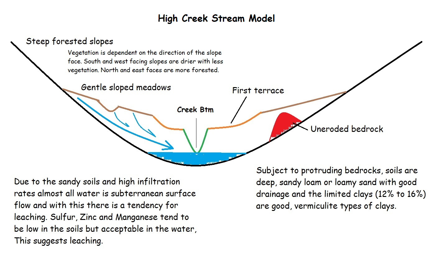
The previously discussed migmatite and ignimbrite rock formations are eroding to form excellent soil horizons. With a mostly black appearance the Highland Vallis soils appear to be predominantly clay but that is not the case. After doing many soils tests, the general texture of the soils are about 2/3 sand size, 1/5 silt size and 1/8 clay size. Remember “sand” is an unusual word in that it has two meanings, one is a size and the other is the chemistry. To be clear, in this paragraph “sand” refers to the size of the particles not the chemistry of the grains. Because the surrounding “mountains” are being eroded into the soils, the soils are very coarse grained and hence 2/3 sand size. As these materials move downslope the overall grain sizes should continue to reduce. The soils are course because they are near to the source of the material – the migmatites and ignimbrites. Generally, these soils are classified as sandy loams.
Cation Exchange Capacity (CEC) is a soil’s ability to hold natural fertilizers like potassium and nitrogen. Higher CEC has higher fertility. Typically, CEC increases in clay soils and decreases in sandy soils. The unique quality of the Highland Vallis soils is that it has the CEC and fertility of a clay soil but the infiltration and fluid mobility of a sandier soil.
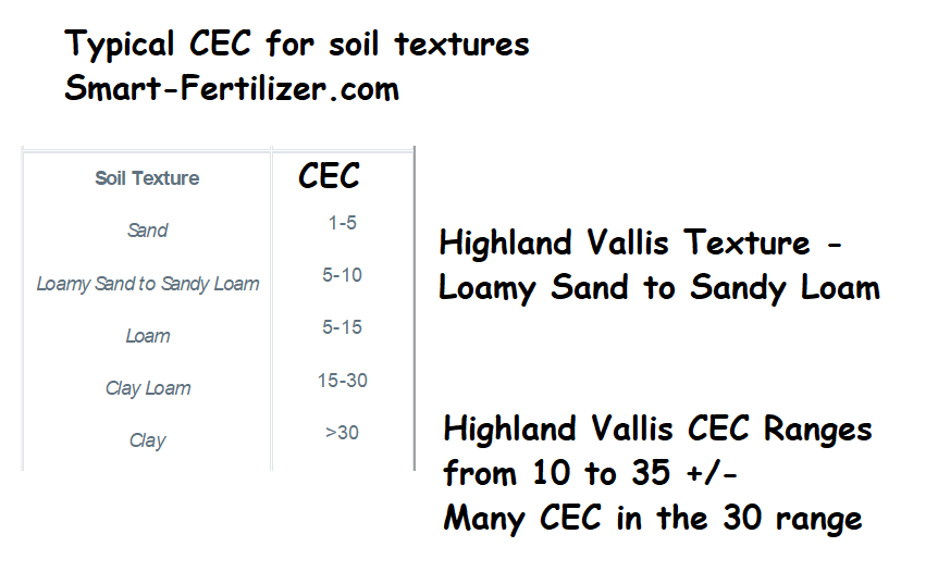
With increasing mobility of fluids in the soils there is also increasing mobility of the ions. The following image indicates some changes in soil chemistry in a vertical section.
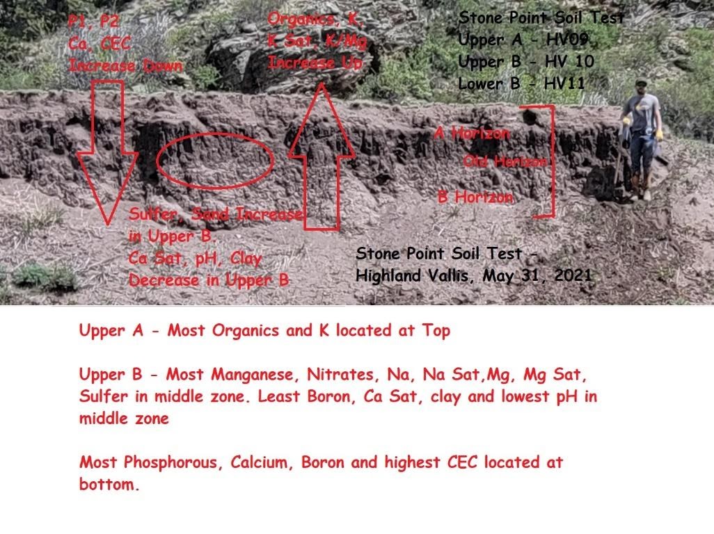
In summary the soils tend to have the good chemistry of a mixed clay but with the infiltration rate of a sandy loam. This means the ranch is a precipitation sponge, minimizing erosionary runoff with good soil chemistry.
Highland Vallis Forage
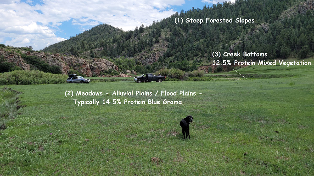
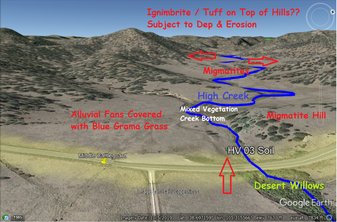
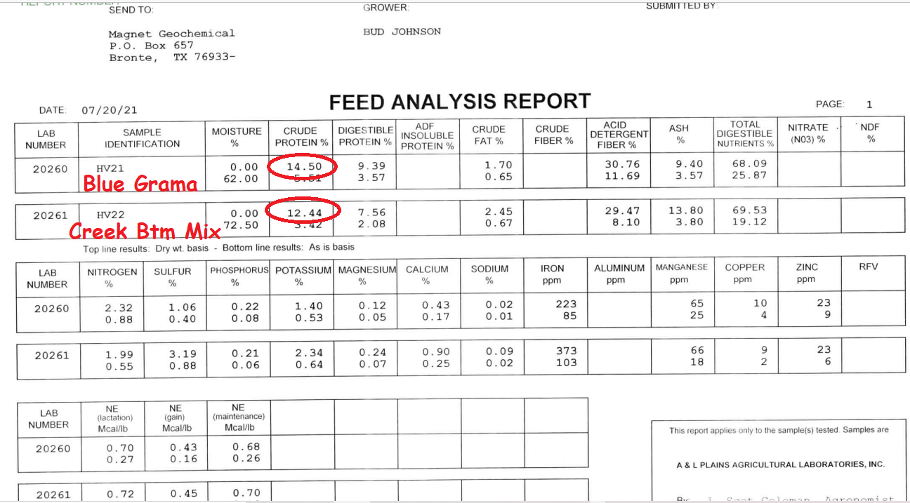
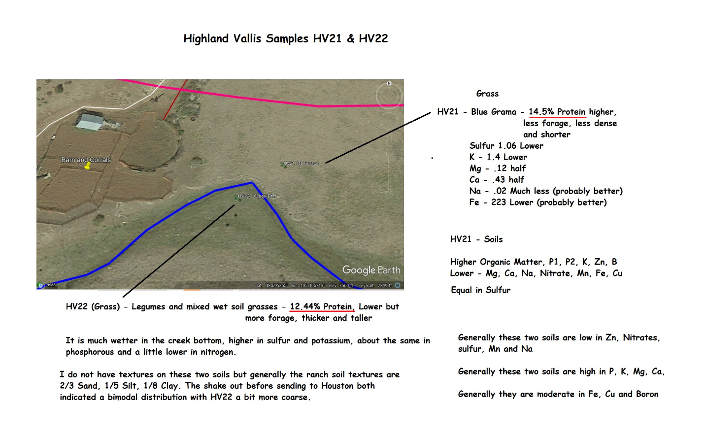
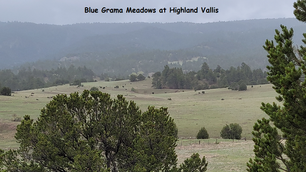
There are three different areas of forages (1) Steep forested slopes. These have good grass but have not yet been tested; (2) alluvial intermediate slopes – meadows; and (3) creek bottoms.
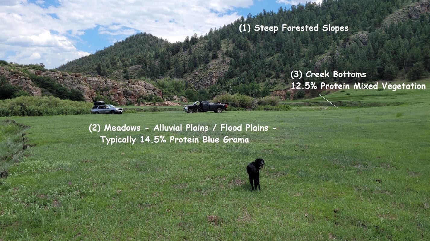
Due to the slightly increased water availability, the creek bottoms have more vegetation volume with a slightly lower protein content while the meadows have slightly lower vegetation content but a higher protein content.
Highland Vallis Water
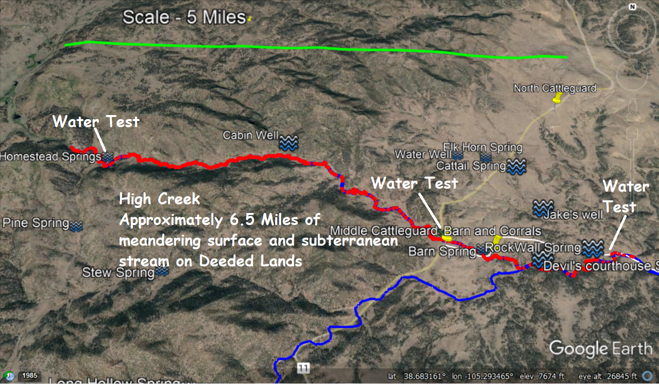
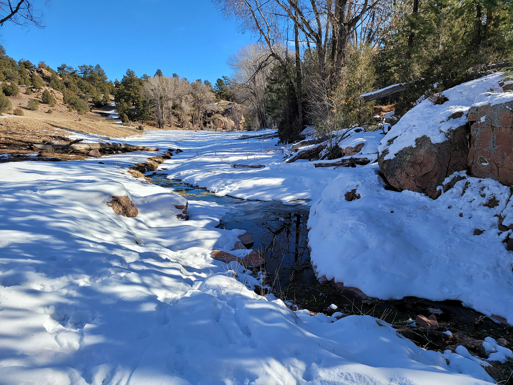
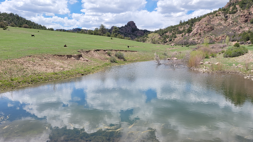
Water Quantity – The primary water source on the ranch is High Creek, a subterranean and surface flow stream which provides ample water for the ranch and more. As previously discussed under soils, the soils materials at Highland Vallis are coarse materials close to the bedrock source material. This “sandy” material allows for most water to migrate underground. Also, an important part of the water flow physics is the stream gradient. As water moves above the ground surface there is no impediment or resistance to stream flow therefore the water can run off faster with the higher mountain gradient. This idea is further magnified by a plant called the Desert Willow. The root system of this plant further slows the downstream movement of the water. You can think of it something like an underground beaver dam. More on this below.
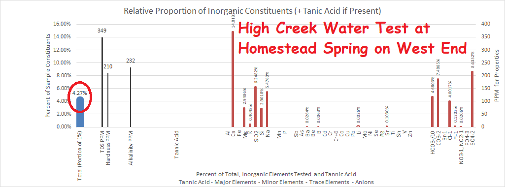
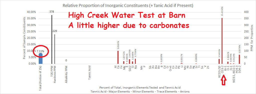
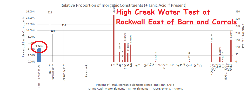
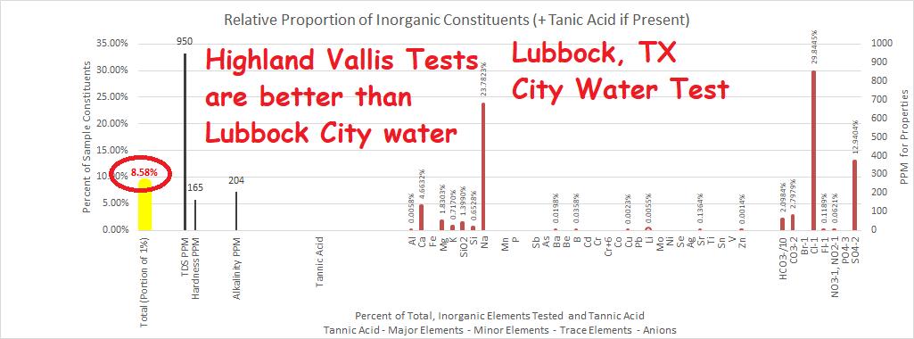
Water Quality – Water quality is excellent the following three water tests are from High Creek, west, east-central and east samples. All three of these samples are better quality water than Lubbock, Texas City Water by comparison.
Desert Willows and Stream Flow
In stream beds with consistent water, Desert Willows which are sometimes called Coyote Willows, are common. They do use a fair amount of water and over the past 70 years there have been attempts to control them to conserve water. Apparently early on there was an issue sometime around the 1950’s drought in which a chemical treatment appeared to have the opposite affect and decrease the amount of available water.
Since that time there has been a discrepancy in considering the willows. Landowners tend to believe in control while conservationists do not lend themselves to control.
Following we will consider these options:
If you consider a stream segment, the amount of water exiting that segment is equal to the amount of water entering it plus any additions from springs, tributaries or other sources, less the amount being dissipated by transpiration, evaporation or other means such as irrigation. In other words, if you have 1000 gallons per minute coming in on the upside then you will have 1000 gallons per minute exiting on the low side unless there are additions or subtractions within that segment. In the case of the willows, the addition of willows uses water through transpiration and decreases the amount of water to exit the stream.
Due to the slightly increased water availability, the creek bottoms have more vegetation volume with a slightly lower protein content while the meadows have slightly lower vegetation content but a higher protein content.
As well as decreasing the water moving through the stream segment by transpiration, it has other impacts as well. Overall each grove of willows behaves as a beaver dam, the thick root system decreases the permeability of the streambed backing up, storing, increasing the potential energy of the immediate area. Essentially the willow has evolved to hoard water for its own use.
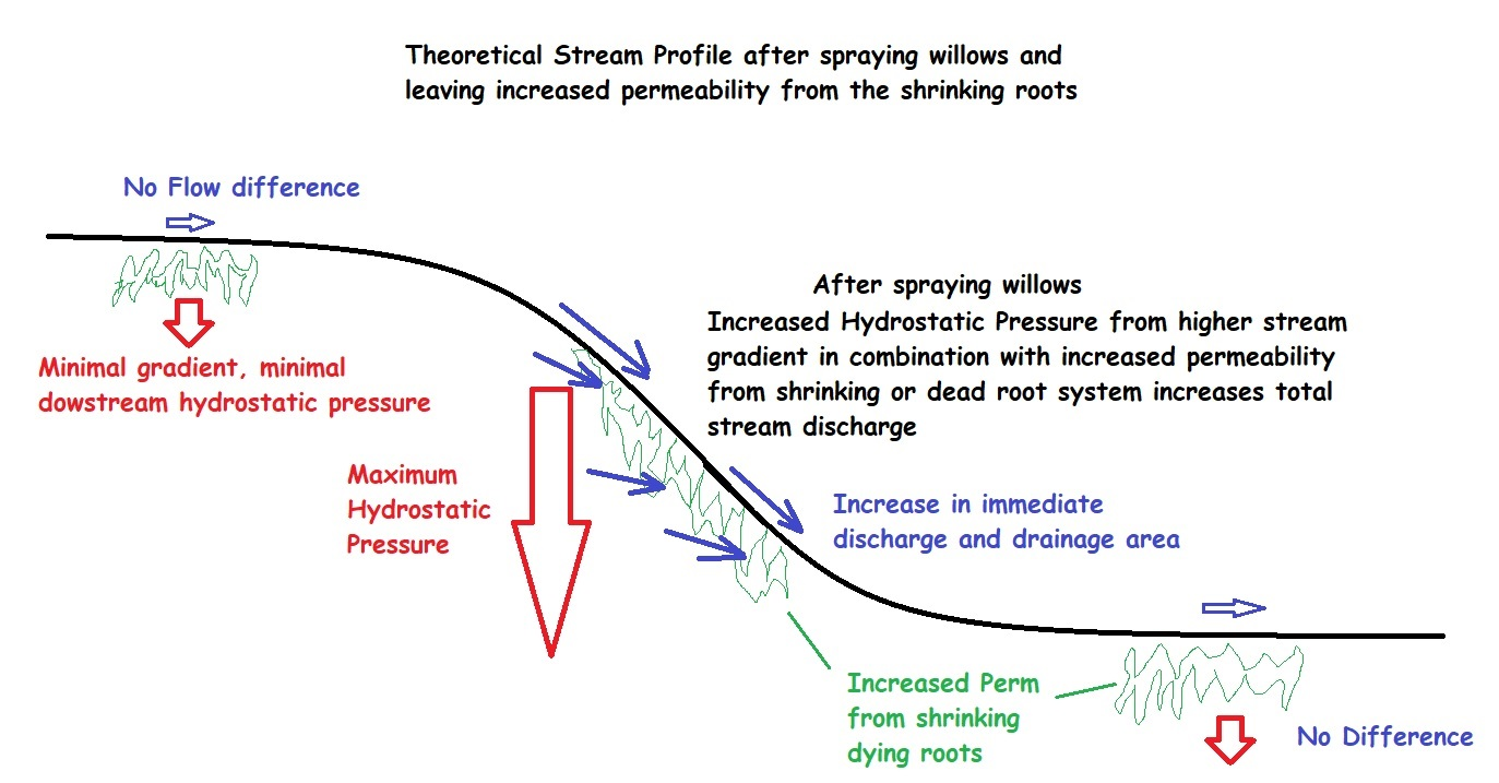
Possibly many years ago, a large area was sprayed to control the willows and the water usage. This would be equivalent to knocking all of the beaver dams at one time. Root shrinkage would have increased permeability within the willow groves. This accelerated the drainage out of the storage area. Looking at it as a segment it would not have made any difference but if at the upper end, it would have accelerated the drainage from the storage area.
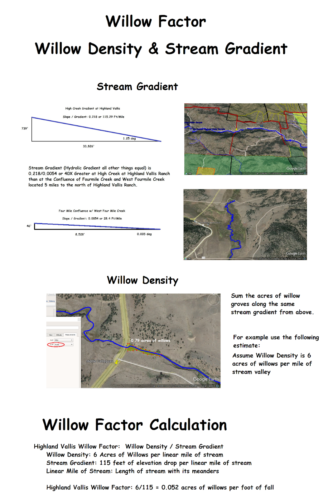
The two main factors affecting the drainage would be the stream gradient and the willow density. If there was no stream gradient, controlling the willows would not make any difference because the water wouldn’t escape anyway. However, as stream gradient increases so does the downward hydrostatic pressure or hydrostatic gradient due to gravity. The higher the stream gradient, the more one must take caution on controlling the willows.
The following illustrations help to walk through the willow density and stream gradient.
Highland Vallis Climate
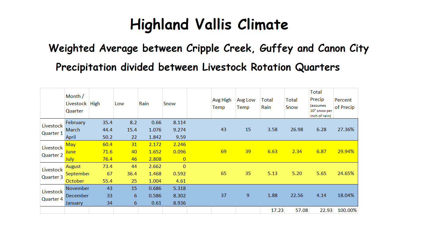
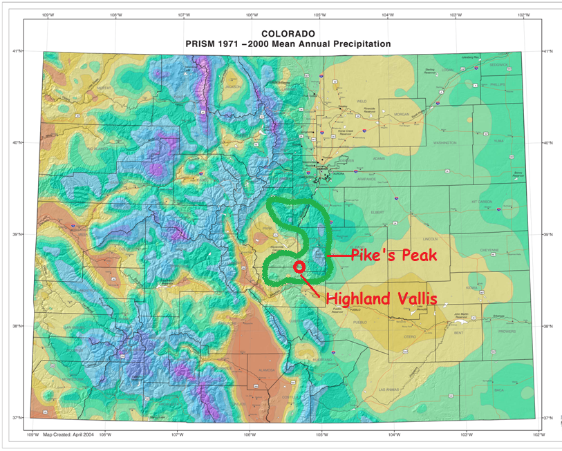
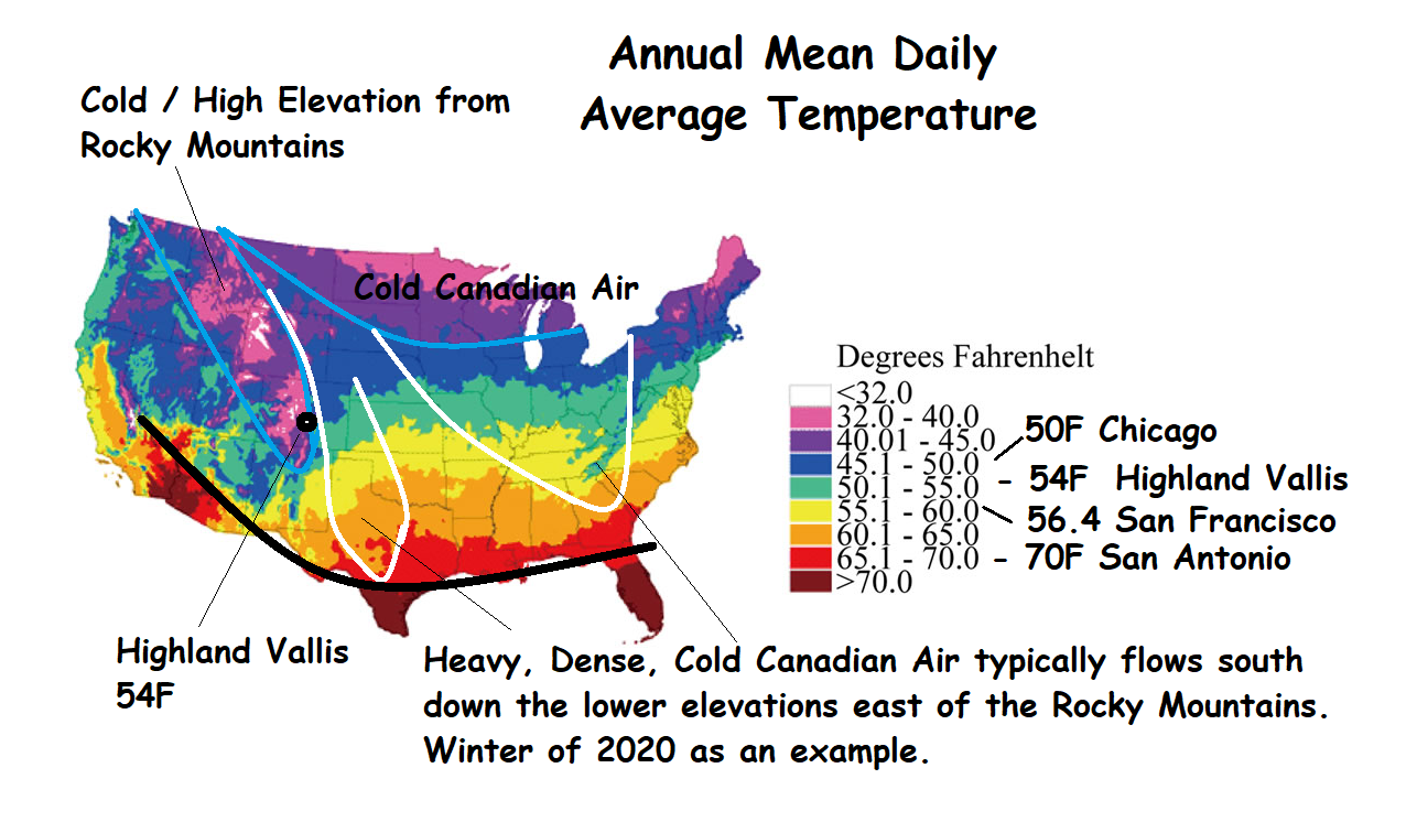
Highland Vallis climate is a fantastic mountain climate with precipitation approximately 75% rain and 25% snow for a total of about 23 inches (58 cm) of precipitation per year. Summer high temperatures run about 70 to 75 degrees Fahrenheit (21-24C) while winter highs are about 40F (4-5C). Every winter evening is cool to cold but most of the really cold Canadian Arctic air (which is heavier and more dense) tends to stay at the lower elevation to the east on the plains. Highland Vallis’ annual mean daily temperature is in the range of Chicago to San Francisco and about 15 degrees cooler than San Antonio and Austin, Texas.
Per the following chart, approximate half the year has a daily high of 70 degrees and daily low of just below 40. The cold season, the other half of the year, is just below 40 for a daily high and below 15 for a nightly low.
Highland Vallis is in an area referred to as the “Banana Belt” the area is a bit warmer and a bit less snow. The snow accumulates on the higher peaks in the area. Its “micro-climate” (climate associated with location and topography) appears to be controlled primarily by Pike’s Peak topography. Both Pacific and Gulf of Mexico moisture tend to rise and condense in association with Pike’s Peak.
Additionally, probably due to the coarse soils and highly fractured bedrock, High Creek does not freeze and the snow on the ranch melts quickly.
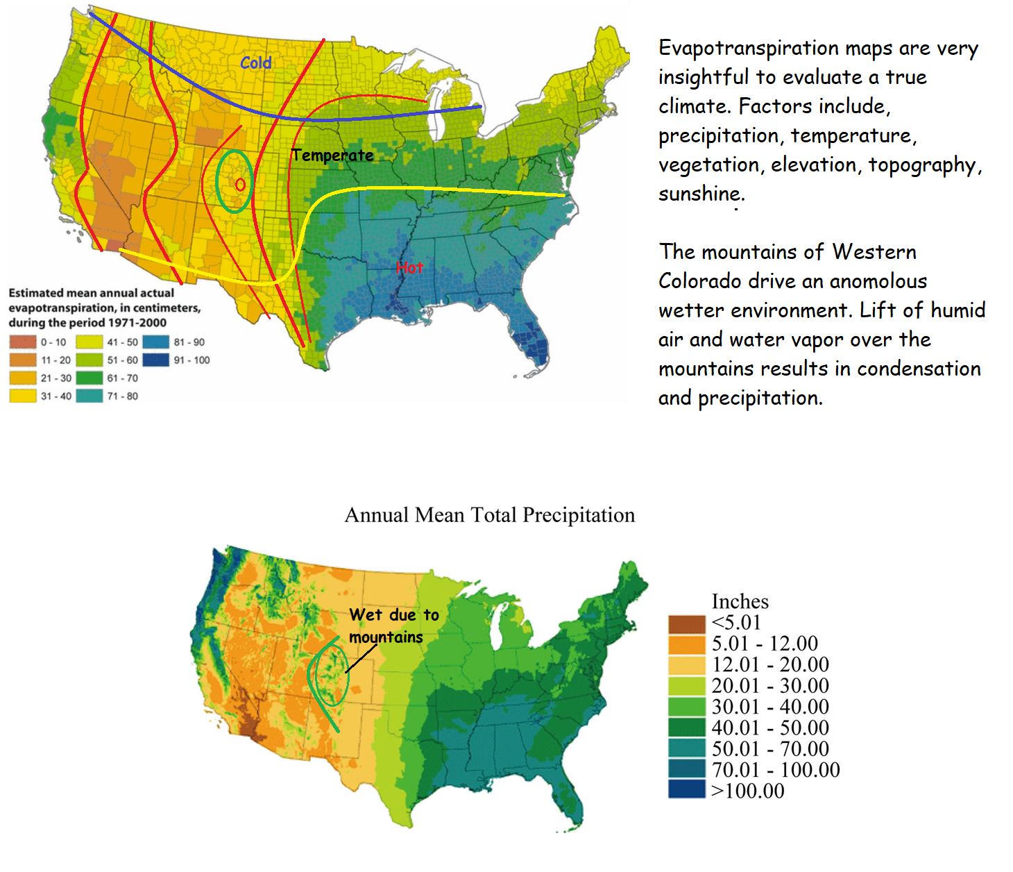
Evapotranspiration maps are very insightful to evaluate a true climate. Factors include, precipitation, temperature, vegetation, elevation, topography, sunshine etc etc.
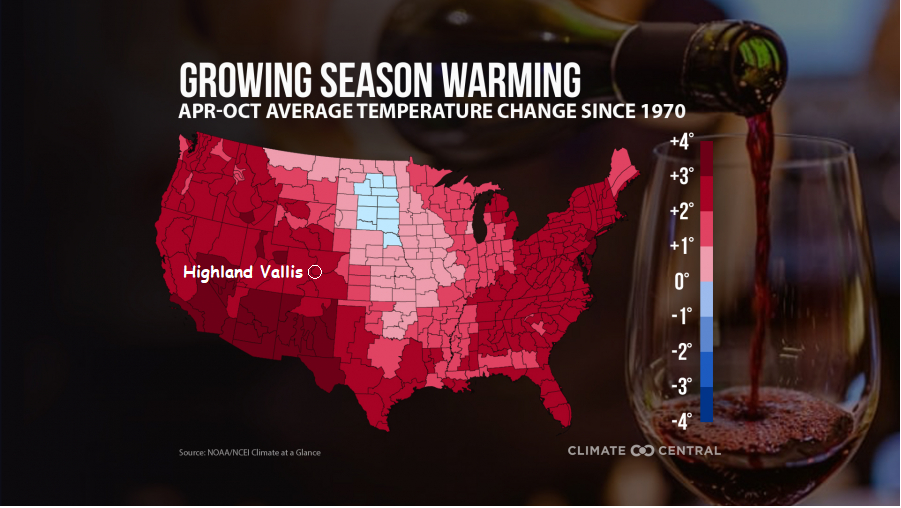
Finally, in considering long term climate changes the two most important factors during warming is to understand that increased heat increases evaporation (from the oceans) and warmer air can retain more water vapor. Together this means added water in the atmosphere. The mountains of Colorado are anomalous or wetter than would be normally predicted in the climate variations across the country. The reason for this is the mountains. As water vapor rises over the mountains, it is cooled and condenses into rain. The mountains also provide a cooler climate, from an agricultural standpoint Highland Vallis will benefit from a longer warmer growing season.
Regardless of the climate, the mountains are not going away which is the immediate and dominant control of the local environment and climate.